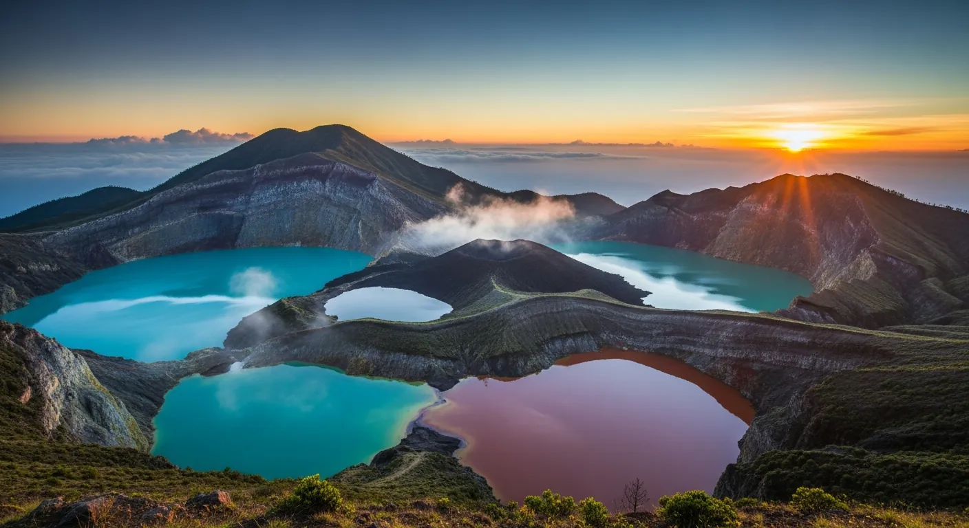
The pre-dawn chill at 1,639 metres above sea level carries the faint scent of sulfur, a constant reminder of the geological forces at play beneath the earth. As the first light touches the eastern horizon, the three crater lakes of Kelimutu begin to emerge from the darkness, their surfaces reflecting the nascent sky in hues that will soon transform with the rising sun. This daily unveiling of a dynamic landscape defines the experience of visiting Kelimutu Lake Flores, a journey into the heart of Flores Island’s volcanic grandeur.
The Volcanic Alchemy of Kelimutu Lake
Kelimutu is a stratovolcano located on central Flores Island, East Nusa Tenggara, Indonesia. The volcano is notable for its three distinct crater lakes, whose colours are not static but undergo periodic transformations. These shifts are attributed to ongoing chemical reactions within the lake waters, driven by variations in dissolved minerals and volcanic gas activity. Scientifically, this phenomenon is a direct result of hydrothermal interactions, where magma-derived fluids interact with the surrounding rock and water, altering the chemical composition and, consequently, the light absorption properties of the lakes. Researchers have documented colour changes ranging from turquoise, green, and blue to red, brown, and even black over periods of weeks or months. The combined surface area of the three Kelimutu crater lakes is approximately 1,051,000 square metres, containing a total water volume of about 1.292 million cubic metres. This substantial body of water provides a vast medium for the observed geological processes. The volcano itself is situated approximately 50 km east of Ende, the capital of Ende Regency, making it a focal point for regional tourism and scientific study. Understanding these processes requires an appreciation for the complex interplay between geology, chemistry, and meteorology, all converging within this singular volcanic system.
Accessing Kelimutu: Routes and Logistics from Moni Village
Moni village serves as the primary base for visitors aiming to experience the Kelimutu crater lakes. Located at an elevation of approximately 800 metres, Moni provides a range of accommodations, from basic guesthouses to more established lodges. The journey from Moni to the Kelimutu National Park entrance typically involves a 30-minute drive on a paved, winding road. Local ojek (motorcycle taxi) services are readily available, with prices generally ranging from IDR 50,000 to IDR 75,000 for a one-way trip, depending on negotiation and time of day. For those preferring more comfort, private car rentals with drivers can be arranged in Moni or larger towns like Ende and Maumere, costing between IDR 500,000 and IDR 800,000 for a full day, including the wait time at the park. The park entrance fee for foreign tourists is typically IDR 150,000 on weekdays and IDR 225,000 on weekends and public holidays. From the park entrance, a well-maintained path and a series of concrete steps lead approximately 1.5 kilometres to the viewpoints overlooking the lakes. This walk usually takes between 20 and 30 minutes, ascending gradually through a cool, forested environment. Starting the ascent around 4:30 AM is recommended for sunrise viewing, allowing ample time to reach the summit platforms before dawn breaks, typically around 5:30 AM to 6:00 AM, depending on the season.
Overland Journeys Through Flores Island
Flores Island offers a compelling overland route for adventurers, with Kelimutu often serving as a key waypoint. The island spans approximately 360 kilometres from east to west, connecting diverse landscapes and cultural sites. Travelers often begin their journey in Maumere (east) or Labuan Bajo (west), the main entry points with airports. From Maumere, the drive to Moni takes approximately 3-4 hours, covering about 100 kilometres. This route traverses lush agricultural areas and offers glimpses of traditional villages. From Labuan Bajo, the journey is considerably longer, often requiring multiple days and overnight stops in towns like Ruteng or Bajawa. The road conditions vary, with well-paved sections interspersed with areas that can be rougher, particularly during the wet season (November to April). Public buses connect major towns, offering a cost-effective but slower option. For instance, a bus from Ende to Moni costs around IDR 30,000 to IDR 50,000 and takes approximately 1.5 to 2 hours. Private transport, while more expensive, offers flexibility and comfort, allowing for stops at attractions such as traditional Ngada villages or coffee plantations. Planning these overland segments requires consideration of travel times, road conditions, and the availability of local transport, contributing to the independent and immersive nature of a Flores exploration.
Kelimutu National Park: Biodiversity and Conservation
Kelimutu National Park, established in 1992, encompasses the tri-colour crater lakes and a surrounding area of significant ecological value. The park is situated on Flores Island in East Nusa Tenggara province, Indonesia, covering an area of approximately 5,356 hectares. Beyond its geological marvels, the park is a biodiversity hotspot, home to numerous endemic species of flora and fauna. The highest peak within the park boundaries is Mount Kelibara, with an elevation of 1,731 metres, offering panoramic views of the surrounding volcanic landscape. The park’s diverse ecosystems range from montane rainforests to sub-alpine vegetation near the crater rims. Notable avian species include the Flores monarch (Monarcha sacerdotum) and the Flores scops owl (Otus alfredi), both endemic to Flores. Mammalian inhabitants include various bat species and civets. Conservation efforts within Kelimutu National Park focus on protecting these unique habitats and mitigating the impacts of tourism. This includes maintaining designated trails, regulating visitor numbers, and implementing waste management protocols. The park’s management also engages local communities in conservation initiatives, fostering a sense of shared responsibility for its natural heritage. Research into the park’s geological and biological systems is ongoing, contributing to a deeper understanding of its ecological processes and informing future conservation strategies. The park’s status as a protected area underscores its importance not just for tourism, but for global biodiversity.
Sunrise Photography at Kelimutu Lake: Techniques and Timing
Capturing the ephemeral beauty of the Kelimutu crater lakes at sunrise demands specific photographic considerations. The optimal window for photography typically occurs between 5:30 AM and 7:00 AM, as the light transitions from deep twilight to the full glow of morning. Essential equipment includes a sturdy tripod to manage low-light conditions and longer exposures, a wide-angle lens (16-35mm equivalent) to encompass the expansive crater views, and a remote shutter release to minimize camera shake. Filters, such as graduated neutral density (GND) filters, can be invaluable for balancing the bright sky with the darker lake surfaces, preventing overexposure of the highlights. Manual mode settings are recommended, allowing precise control over aperture (typically f/8 to f/11 for depth of field), shutter speed (varying from several seconds in pre-dawn to fractions of a second post-sunrise), and ISO (kept as low as possible, e.g., 100-400, to minimize noise). The three lakes, Tiwu Ata Bupu (Lake of Old People), Tiwu Ko’o Fai Nuwa Muri (Lake of Young Men and Maidens), and Tiwu Ata Polo (Enchanted Lake), present distinct photographic opportunities. Their individual colour shifts, which can vary day by day, require photographers to adapt quickly. Compositions often benefit from including the surrounding volcanic peaks and the sparse, gnarled trees that frame the craters, adding context and depth to the landscape. Patience is paramount, as cloud cover can obscure the view, and waiting for breaks in the mist often yields the most dramatic results. Understanding the specific light conditions and the unique characteristics of each lake is crucial for successful sunrise photography at Kelimutu.
Beyond Kelimutu: Exploring East Nusa Tenggara’s Volcanic Arc
East Nusa Tenggara province is a region defined by its volcanic geology, with Kelimutu being one of many active and dormant volcanoes that shape its landscape. The province extends across numerous islands, each bearing the mark of intense geological activity. Approximately 50 km east of Ende, Kelimutu volcano is part of a larger chain of volcanoes that stretches across the Indonesian archipelago, a segment of the Pacific Ring of Fire. Other notable volcanoes in the region include Mount Egon, near Maumere, which last erupted in 2016, and Inierie, Flores’ highest active volcano, reaching 2,245 metres. The volcanic soil in East Nusa Tenggara contributes to the region’s agricultural fertility, supporting crops like coffee, rice, and spices. The presence of these volcanoes also influences the local culture, with many traditional beliefs and rituals intertwined with the mountains and their powerful forces. For instance, local communities near Kelimutu hold ceremonies to honour the spirits believed to reside within the lakes. Exploring this wider volcanic arc offers insights into the geological processes that have shaped Indonesia for millennia and continue to do so. This region presents a unique opportunity for geo-tourism, where visitors can witness firsthand the dynamic interplay between earth’s internal forces and the surface landscape. The geological diversity of East Nusa Tenggara, from its active craters to its ancient lava flows, provides a comprehensive narrative of volcanic evolution. Kelimutu and its sister volcanoes are integral to this narrative, offering both scientific interest and profound natural beauty. The region’s geological significance is further detailed on platforms like Wikidata, providing comprehensive data on its features.
The enduring allure of Kelimutu Lake lies not just in its vibrant hues, but in the profound geological narrative it presents. Each sunrise reveals a new facet of this dynamic landscape, inviting contemplation and discovery. Plan your journey to the tri-colour crater lakes and look closer into the wonders of Flores Island. Visit Kelimutu Lake Flores for comprehensive planning resources.
Kelimutu’s Geological Enigma: Why the Colours Shift
Kelimutu’s three volcanic crater lakes are a geological marvel, their colours periodically changing in a display that fascinates scientists and travelers alike. This dynamic phenomenon isn’t magic; it’s a direct result of intricate chemical reactions involving dissolved minerals and volcanic gases beneath the surface. The volcano, situated on central Flores Island, continuously releases gases, which then interact with various elements present in the lake water, such as iron and sulfur. These interactions create different chemical compounds, each reflecting light at distinct wavelengths, thus producing the vibrant reds, greens, blues, and even browns witnessed by visitors. Understanding this delicate balance provides a deeper appreciation for the raw power of the Earth.
The specific colour at any given time depends on the oxidation-reduction state of the lake, influenced by gas flux and water chemistry. One day you might see Tiwu Ata Bupu, the Lake of Old People, a deep turquoise; the next, it could shift to a murky brown or even a striking red. These fluctuations are natural and unpredictable, adding to Kelimutu’s allure. Geologists monitor these changes, gathering details about the volcano’s subterranean activity. For visitors, it’s a reminder that they are witnessing a living, breathing geological process, a stark contrast to the static beauty of many other natural wonders.
Sunrise at Kelimutu: Practical Planning Details for Dawn
Witnessing dawn over Kelimutu’s crater lakes is a quintessential Flores experience, demanding careful practical planning. Most travelers aim to arrive at the viewpoint just before sunrise, typically meaning a very early start from nearby Moni or even Ende. The journey from Moni to the Kelimutu National Park entrance takes about 45 minutes to an hour by scooter or rented car. From the entrance, a well-maintained path leads up to the various viewpoints overlooking the three lakes. Allow an additional 30-45 minutes for this walk, especially in the pre-dawn darkness. Bring a headlamp; the path is unlit.
The warmth of a jacket is essential; mornings at this elevation (the summit area is considerably higher than the park entrance) can be surprisingly cool, even in November. After sunrise, the light dramatically transforms the landscape, offering different photographic opportunities. Consider hiring a local tour guide for insights into the culture and traditions associated with the lakes. Afterward, many travelers head back to Moni for breakfast. Flights into Ende (ENE) are the most common entry point for those planning an overland trip to Flores, making Kelimutu an accessible, though early-morning, adventure.
Kelimutu’s Scale: Understanding the Lakes and Summit
Kelimutu is not just a collection of pretty lakes; it’s a significant volcanic complex within Kelimutu National Park, located on Flores Island in East Nusa Tenggara province. While the three crater lakes are the main attraction, the park itself is expansive. The highest peak within the park boundaries is Mount Kelibara, standing at an elevation of 1,731 metres. This context helps travelers appreciate the geological grandeur of the area. The crater lakes themselves, though visually distinct, share a connected subsurface volcanic system.
Their combined surface area is approximately 1,051,000 square metres, a vast expanse of water perched atop the volcano. The total water volume within these three lakes is about 1.292 million cubic metres, a substantial reservoir held within volcanic calderas. These impressive statistics underscore the scale of Kelimutu. The edge of the craters offers dramatic perspectives, but visitors must respect safety barriers. It is a powerful landscape, a place where the Earth’s internal forces are visibly at play, making it a unique destination for volcano and crater-lake enthusiasts.
Navigating Kelimutu: Access and Safety for Travelers
Accessing Kelimutu requires a journey, but it’s well worth the effort for volcano and crater-lake enthusiasts. The volcano is located about 50 km east of Ende, the capital of Ende Regency. Most visitors stay in Moni, a small village much closer to the park entrance, offering guesthouses and basic amenities. From Moni, the final ascent to the crater rim is typically done by scooter or car, followed by a walk. The roads are generally paved but can be winding and steep in sections, especially in the pre-dawn darkness.
Safety is paramount at Kelimutu. While the viewpoints are generally secure, visitors should always remain on marked paths and behind safety barriers. The edges of the craters can be unstable, and falling into the lakes is extremely dangerous due to steep slopes and toxic gases. There are no fences directly around the lake edges, only at designated viewing platforms. Always be aware of your surroundings, especially when walking in low light conditions. Respecting the local tradition and the natural environment ensures a safe and memorable experience for all travelers.
Beyond the Lakes: Kelimutu’s Cultural Significance and Local Traditions
Kelimutu is more than just a geological wonder; it holds profound cultural significance for the local Lio people. According to their tradition, the three lakes are the spiritual resting places for the souls of the deceased. Tiwu Ata Bupu, the Lake of Old People, is believed to be where the souls of the elders and respected ancestors reside. The other two lakes are for the young and for those who committed evil deeds, their colours reflecting the spiritual state of the souls within. This deep-rooted belief system is an integral part of the local culture, impacting how the lakes are revered and protected.
Local guides often share these stories, adding a rich layer of cultural understanding to the natural beauty. Visitors are encouraged to respect these traditions, which have been passed down through generations. You might observe small offerings or rituals performed by local villagers at the park entrance or near the lake viewpoints. These cultural details are often missed by travelers solely focused on photography, but they provide a powerful connection to the land and its people. Understanding the spiritual importance enhances the entire experience, moving beyond mere sightseeing to a deeper engagement with Flores’ unique heritage.
Seasonal Variations and Photography Tips at Kelimutu
Kelimutu’s ever-changing colours present a unique challenge and opportunity for sunrise photographers. While the lakes can fluctuate in colour at any time, certain periods might offer different atmospheric conditions. The dry season (roughly May to September) generally provides clearer skies, ideal for crisp dawn shots. However, the wet season (October to April), particularly around November, can bring dramatic cloud formations and mist, adding an ethereal quality to the landscape. Prepare for varying weather conditions regardless of the season; the mountain environment is unpredictable.
For the best photographs, arrive early to secure a good spot, especially if you’re part of a tour group. Long exposures at dawn can capture the subtle shifts in light and colour. After sunrise, as the light strengthens, the true vibrancy of the red, brown, or turquoise lakes becomes more apparent. Experiment with different angles from the various viewpoints. A wide-angle lens is useful for capturing the expansive landscape, while a telephoto can isolate interesting details. Check a recent blog or travel forum for the most up-to-date colour reports, though remember that the lakes can change quickly.